Project implementation
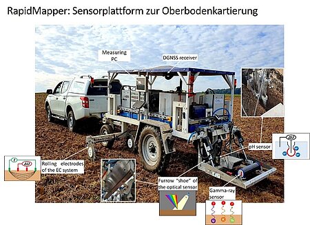
A core element of I4S is the development of a multi-sensor platform for high-resolution topsoil mapping. The sensor modules developed by the I4S partners, which are based on various measuring principles and can record different soil properties relevant to soil fertility, are to be integrated into the RapidMapper and tested in the field.
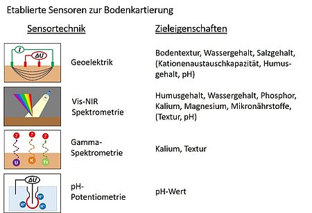
In an initial development phase, the RapidMapper was equipped with the following four sensor technologies:
A geoelectric sensor measures the apparent electrical conductivity of the soil. This conductivity is influenced by a variety of soil properties, in particular soil texture, water content, salt content and indirectly also by the cation exchange capacity (CEC), humus content and pH value. Due to this complexity, it is often difficult to attribute variations in electrical conductivity to a single cause and draw agronomic conclusions.
An optical spectrometer, which measures in the visual and near infrared range, is used to collect large amounts of data that allow conclusions to be drawn about humus content, water content and nutrient content. It also provides information on the texture and pH value of the soil
A gamma spectrometer records the soil's natural gamma radiation from various isotopes. These measurements can provide valuable information on soil texture and potassium content, which is important for the plant's nutrient management.
Finally, a pH sensor measures soil acidity, which directly or indirectly influences a number of other soil properties and thus soil fertility.
Together, these sensors enable a comprehensive analysis of agronomically relevant soil properties, which are essential for site-specific soil management. The RapidMapper multi-sensor platform can be towed by either an off-road vehicle or a tractor. During the measurements, the data from the individual sensors is stored on a central computer together with the position data from a highly accurate differential GPS. By combining different sensors on one platform, not only is the workload of sensor mapping reduced, but the fusion of the different sensor data also significantly increases the quality of soil property and demand maps, leading to better agronomic decisions.
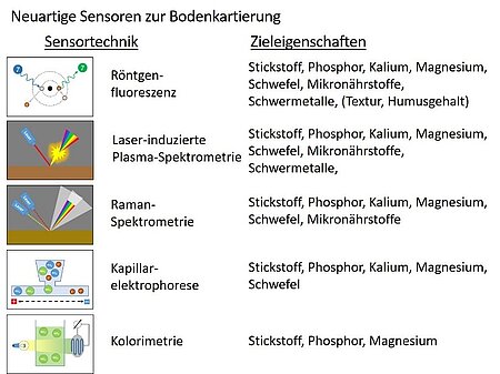
In addition to established sensor technologies, the team in the I4S project is also working on new types of sensors that have not yet been tested in mobile soil mapping. These innovative technologies include X-ray fluorescence, laser-induced plasma spectroscopy, Raman spectroscopy, electrophoresis and colorimetry. The use of these new soil sensors is expected to further improve the quality of soil property maps while expanding the range of predictable soil properties. These advances could be instrumental in developing an even more sophisticated understanding of soil conditions and processes, which is important for further optimization of agricultural practices. The combination of traditional and novel sensor technologies opens up promising prospects for more precise and sustainable soil management.
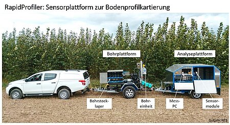
In addition to the RapidMapper for topsoil mapping, a second sensor system is being developed in I4S that can be used to scan soil profiles down to a depth of one meter cm by cm. This method will make it possible to record more detailed soil data of the entire root zone. In the future, this diverse data will be used to create 3D soil maps together with the RapidMapper's high-resolution topsoil mapping. These comprehensive maps provide valuable insights into nutrient stocks and their distribution in the soil. This will enable farmers to plan their nutrient supply even more specifically and further increase the efficiency of their cultivation.
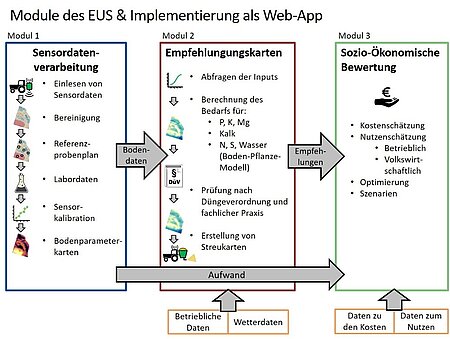
Another focus of I4S is on the further development of soil-plant models that simulate the dynamics of nutrients and water over the course of the growing season. These models are able to simulate the development of highly dynamic soil properties, such as nitrogen or water, over the course of the vegetation period in high spatial and temporal resolution in order to derive management recommendations. Based on the sensor data and the dynamic models, I4S is ultimately developing a user-friendly decision support system (EUS) with which farmers and agricultural advisors can create the aforementioned soil property maps and high-resolution fertilizer application maps. The EUS comprises three modules. Module 1 covers the individual steps of sensor data processing, from data cleansing and reference sampling planning to sensor calibration and the creation of soil maps. This soil data then flows into Module 2, where various fertilization algorithms are used to calculate the nutrient and lime requirements and generate spreading maps. Module 3 will ultimately be used for socio-economic evaluation in order to compare the costs of sensor mapping with the operational and economic benefits and to create a sound basis for decision-making. The main vision behind this is to further facilitate the creation of high-resolution soil maps from sensor data and the derivation of management recommendations and to ensure that sensor-based soil mapping is used more widely in practical agriculture.
