Sensor-based soil mapping for precision agriculture
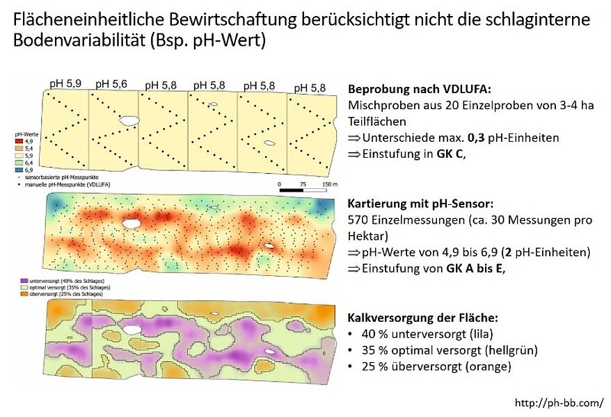
In practical agriculture, uniform land management is still common practice. However, a major problem here is that the soil variability within a field is not sufficiently taken into account. Conventionally, a field is divided into subplots of 3 to 4 hectares, from which composite samples are taken and analyzed in the laboratory. The problem can be illustrated as follows using the example of a test field: After conventional sampling, the test plot shows a relatively uniform pH value of 5.6 to 5.9, which corresponds to a pH variability of only 0.3 units. Accordingly, the field is classified as lime supply class C, which means that only maintenance liming is required.
Differences between conventional sampling and precise sensor technology
However, if we look at the actual pH variability of the field, which was mapped using a pH sensor and almost 600 individual measurements, a completely different picture emerges: the pH value varies between 4.9 and 6.9 with a fluctuation of 2 units. This means that the lime supply of the soil ranges from A to E, which means that in some areas a recovery liming is necessary, while in others no additional liming should be carried out.


Precise soil management for sustainable yield increases and resource conservation
If this highly variable field is now limed on the basis of the conventional sampling scheme, only 35% of the field is optimally supplied. At the same time, 40% remains under-supplied, which means that the yield potential is not exploited, while 25% is over-supplied and therefore wastes resources and risks yield losses. More precise and site-specific management is therefore urgently required in order to use soil resources more efficiently and increase yields sustainably.
We have examined the proportion of soil texture that has been misjudged in the past on a practical farm. The results show that on average only 40% of the areas are correctly classified. The majority of the areas were overestimated, which means that a higher soil group (finer texture) was assumed than was actually present. This incorrect assessment has led to a systematic overestimation of the lime requirement, an oversupply and thus to potential yield losses. A more precise classification of soils is therefore essential for sustainable, resource-conserving and yield-optimized soil management.
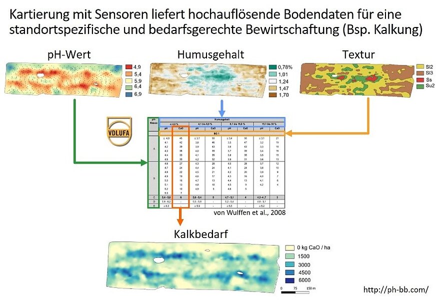
To do this, however, farmers need high-resolution information on the variability of soil properties. However, this cannot be achieved through conventional soil sampling and subsequent standard laboratory analysis. Soil mapping with sensors offers a fast and cost-effective alternative. With the help of sensor data, high-resolution soil property maps can be created that make it possible to determine the nutrient and lime requirements for specific sites and take them into account when fertilizing. This leads to a more efficient use of inputs and natural resources, to a sustainable optimization of yields and to a reduced environmental impact.