Projektumsetzung
Ein Kernelement von I4S ist die Entwicklung einer Multisensorplattform zur hochauflösenden Oberbodenkartierung. Auf dem sogenannten RapidMapper sollen die von den I4S-Partnern entwickelten Sensormodule, die auf verschiedenen Messprinzipien beruhen und unterschiedliche, für die Bodenfruchtbarkeit relevante, Bodeneigenschaften erfassen können, integriert und im Feldeinsatz getestet werden.
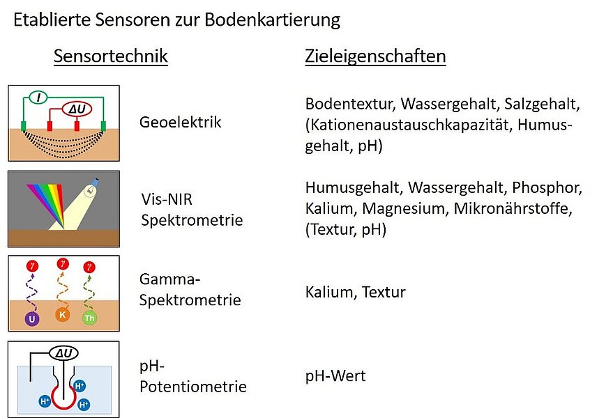
In einer ersten Entwicklungsphase wurde der RapidMapper mit den folgenden vier Sensortechnologien ausgerüstet:
- Ein geoelektrischer Sensor misst die scheinbare elektrische Leitfähigkeit des Bodens. Diese Leitfähigkeit wird durch eine Vielzahl von Bodeneigenschaften beeinflusst, insbesondere durch Bodentextur, Wassergehalt, Salzgehalt und indirekt auch durch die Kationenaustauschkapazität (KAK), den Humusgehalt und den pH-Wert. Aufgrund dieser Vielschichtigkeit ist es oft schwierig, Variationen in der elektrischen Leitfähigkeit einer einzigen Ursache zuzuordnen und daraus agronomische Schlüsse zu ziehen.
- Ein optisches Spektrometer, das im visuellen und nahen Infrarotbereich misst, dient zur Erfassung großer Datenmengen, die Aussagen über Humusgehalt, Wassergehalt und Nährstoffgehalte ermöglichen. Darüber hinaus liefert es auch Informationen zur Textur und zum pH-Wert des Bodens
- Ein Gammaspektrometer erfasst die natürliche Gammastrahlung des Bodens von verschiedenen Isotopen. Diese Messungen können wertvolle Hinweise zur Bodentextur und zum Kaliumgehalt geben, was für das Nährstoffmanagement der Pflanze von Bedeutung ist.
- Ein pH-Sensor misst schließlich die Bodenazidität, die eine Reihe anderer Bodeneigenschaften und damit die Bodenfruchtbarkeit direkt oder indirekt beeinflusst.

Zusammen ermöglichen diese Sensoren eine umfassende Analyse agronomisch relevanter Bodeneigenschaften, die für ein standortspezifisches Bodenmanagement unerlässlich sind. Die RapidMapper Multisensorplattform kann entweder von einem Geländewagen oder einem Traktor gezogen werden. Während der Messungen werden die Daten der einzelnen Sensoren zusammen mit den Positionsdaten eines hochgenauen differentiellen GPS auf einem Zentralcomputer gespeichert. Durch die Kombination verschiedener Sensoren auf einer Plattform wird nicht nur der Arbeitsaufwand bei der Sensorkartierung verringert, sondern durch die Fusion der verschiedenen Sensordaten auch die Qualität der Bodeneigenschafts- und Bedarfskarten erheblich gesteigert, was zu besseren agronomischen Entscheidungen führt.

Neben den etablierten Sensortechnologien arbeitet das Team im Projekt I4S auch an neuartigen Sensoren, die bisher noch nicht in der mobilen Bodenkartierung getestet wurden. Zu diesen innovativen Technologien zählen unter anderem Röntgenfluoreszenz, laserinduzierte Plasmaspektroskopie, Raman-Spektroskopie, Elektrophorese und Kolorimetrie. Durch den Einsatz dieser neuen Bodensensoren wird erwartet, die Qualität der Bodeneigenschaftskarten weiter zu verbessern und gleichzeitig die Palette der vorhersagbaren Bodeneigenschaften zu erweitern. Diese Fortschritte könnten entscheidend dazu beitragen, ein noch differenzierteres Verständnis der Bodenbedingungen und –prozesse zu entwickeln, was für die weitere Optimierung landwirtschaftlicher Praktiken von großer Bedeutung ist. Die Kombination traditioneller und neuartiger Sensortechnologien eröffnet vielversprechende Perspektiven für eine präzisere und nachhaltigere Bodenbewirtschaftung.

Zusätzlich zum RapidMapper für die Oberbodenkartierung wird in I4S ein zweites Sensorsystem entwickelt, mit dem Bodenprofile bis in eine Tiefe von einem Meter cm für cm abgescannt werden können. Diese Methode wird es ermöglichen, detailliertere Bodendaten des gesamten Wurzelraums zu erfassen. Diese vielfältigen Daten sollen in Zukunft dafür genutzt werden, zusammen mit der hochaufgelösten Oberbodenkartierung des RapidMapper 3D-Bodenkarten zu erstellen. Diese umfassenden Karten bieten wertvolle Einblicke in die Nährstoffvorräte und deren Verteilung im Boden. Dadurch können Landwirte die Nährstoffversorgung noch gezielter planen und die Effizienz ihrer Bewirtschaftung weiter steigern.

Ein weiterer Fokus von I4S liegt auf der Weiterentwicklung von Boden-Pflanze-Modellen, die die Dynamik von Nährstoffen und Wasser im Laufe der Vegetationsperiode simulieren. Diese Modelle sind in der Lage, die Entwicklung hochdynamischer Bodeneigenschaften, wie z.B. Stickstoff oder Wasser im Laufe der Vegetationsperiode in räumlich und zeitlich hoher Auflösung zu simulieren, um daraus Bewirtschaftungsempfehlungen abzuleiten. Auf Grundlage der Sensordaten und der dynamischen Modelle entwickelt I4S letztlich ein nutzerfreundliches Entscheidungsunterstützungssystem (EUS) mit dem Landwirte und landwirtschaftliche Berater die erwähnten Bodeneigenschaftskarten und hochaufgelösten Düngeapplikationskarten erstellen können. Das EUS umfasst drei Module. Modul 1 umfasst die einzelnen Schritte der Sensordatenverarbeitung von der Datenbereinigung, über die Planung der Referenzbeprobung bis hin zur Sensorkalibration und Erstellung der Bodenkarten. Diese Bodendaten fließen dann in Modul 2, wo mithilfe verschiedener Düngealgorithmen die Nährstoff- und Kalkbedarfe berechnet und daraus Streukarten generiert werden. Modul 3 soll letztlich der sozio-ökonomischen Bewertung dienen, um die Kosten für die Sensorkartierung dem betrieblichen und volkswirtschaftlichen Nutzen gegenüberzustellen und eine fundierte Entscheidungsgrundlage zu schaffen. Die große Vision dahinter ist, das Erstellen hochauflösender Bodenkarten aus Sensordaten und das Ableiten von Bewirtschaftungsempfehlungen weiter zu erleichtern und zu erreichen, dass die sensorbasierte Bodenkartierung stärker in der praktischen Landwirtschaft Anwendung findet.